भूविज्ञान में रिमोट सेंसिंग, भूवैज्ञानिक विज्ञान में उपयोग की जाने वाली रिमोट सेंसिंग है जो डेटा अवलोकन विधि के रूप में क्षेत्र अवलोकन के लिए पूरक है, क्योंकि यह उन क्षेत्रों की भूवैज्ञानिक विशेषताओं का मानचित्रण करने की अनुमति देता है, जहां बिना क्षेत्रों के भौतिक संपर्क के क्षेत्रों का पता लगाया जाता है। पृथ्वी के कुल सतह क्षेत्र का लगभग एक-चौथाई भाग उजागर भूमि है जहाँ सुदूर संवेदन के माध्यम से विस्तृत पृथ्वी अवलोकन से जानकारी निकालने के लिए तैयार है। रिमोट सेंसिंग का संचालन सेंसर द्वारा विद्युत चुम्बकीय विकिरण का पता लगाने के माध्यम से किया जाता है। विकिरण स्वाभाविक रूप से खट्टा (निष्क्रिय रिमोट सेंसिंग) हो सकता है, या मशीनों (सक्रिय रिमोट सेंसिंग) द्वारा उत्पादित और पृथ्वी की सतह से परिलक्षित होता है। विद्युत चुम्बकीय विकिरण दो मुख्य चर के लिए एक सूचना वाहक के रूप में कार्य करता है। सबसे पहले, विभिन्न तरंग दैर्ध्य पर परावर्तन की तीव्रता का पता लगाया जाता है, और एक वर्णक्रमीय परावर्तन वक्र पर प्लॉट किया जाता है। [१] यह वर्णक्रमीय फिंगरप्रिंट लक्ष्य वस्तु की सतह के भौतिक-रासायनिक गुणों द्वारा नियंत्रित होता है और इसलिए खनिज पहचान और इसलिए भूगर्भीय मानचित्रण में मदद करता है, उदाहरण के लिए हाइपरस्पेक्ट्रल इमेजिंग द्वारा। दूसरा, सेंसर से वापस और विकिरण के दो-तरफ़ा यात्रा समय सक्रिय रिमोट सेंसिंग सिस्टम में दूरी की गणना कर सकते हैं, उदाहरण के लिए, इंटरफेरोमेट्रिक सिंथेटिक-एपर्चर रडार। यह भू-गति के भू-वैज्ञानिक अध्ययन में मदद करता है, और इस प्रकार भूस्खलन, भूकंप आदि से जुड़े विकृति को रोशन कर सकता है
रिमोट सेंसिंग डेटा भूवैज्ञानिक मानचित्रण, भूवैज्ञानिक खतरों और आर्थिक भूविज्ञान (यानी, खनिजों, पेट्रोलियम, आदि के लिए अन्वेषण) से संबंधित अध्ययनों में मदद कर सकते हैं। ये भूवैज्ञानिक अध्ययन आमतौर पर विद्युत चुम्बकीय विकिरण की छोटी तरंगदैर्घ्य के अनुसार वर्गीकृत किए गए उपकरणों की एक भीड़ को नियुक्त करते हैं जो विभिन्न। उपकरण संवेदनशील होते हैं। धीरे-धीरे तरंग दैर्ध्य खनिज के पैमाने तक साइट के लक्षण वर्णन के लिए उपयोगी होते हैं, जबकि लंबे समय तक तरंगदैर्ध्य बड़े पैमाने पर सतह की जानकारी प्रकट करते हैं, जैसे। क्षेत्रीय तापीय विसंगतियाँ, सतह की खुरदरापन, आदि ऐसी तकनीकें विशेष रूप से दुर्गम क्षेत्रों की खोज के लिए फायदेमंद हैं, और पृथ्वी के अलावा अन्य ग्रहों। भूविज्ञान के लिए परदे के पीछे संवेदन, जैसे मिट्टी और वनस्पति जो कि विभिन्न प्रकार की चट्टानों से ऊपर बढ़ती हैं, यह भी मदद कर सकता है। अंतर्निहित भूगर्भीय पैटर्न का अनुमान लगाते हैं। संवेदन संबंधी डेटा को अक्सर भौगोलिक सूचना प्रणाली (जीआईएस) उपकरणों का उपयोग करके कल्पना की जाती है। इस तरह के उपकरण मात्रात्मक विश्लेषणों की एक श्रृंखला की अनुमति देते हैं, जैसे कि मुख्य विशेषताओं को प्रकट करने के लिए झूठी रंगीन छवि बनाने के लिए विभिन्न रेड-ग्रीन-ब्लू कॉन्फ़िगरेशन में एकत्रित डेटा सेट के विभिन्न तरंग दैर्ध्य का उपयोग करना। इस प्रकार, छवि प्रसंस्करण एकत्रित छवि से मापदंडों को समझने और जानकारी निकालने के लिए एक महत्वपूर्ण कदम है।
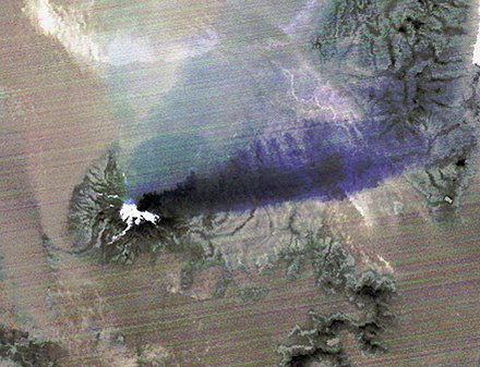
चिली में कैलबुको ज्वालामुखी के 2015 विस्फोट पर कब्जा करने वाली एक ASTER रात के समय की थर्मल इंफ्रारेड इमेज। शिखर पर गर्म विस्फोट सामग्री सफेद (गर्म) में दिखाई देती है, एक बैंगनी प्लम दाईं ओर स्ट्रीमिंग करती है, यह दर्शाता है कि यह राख से लदी हुई है।
Remote sensing in geology is the remote sensing used in geological science as a data observation method complementary to field observation, as it allows mapping of the geological features of areas without physical contact with areas Areas of are explored. Approximately one-fourth of the total surface area of the Earth is exposed land, which is ready to extract information from detailed earth observation through remote sensing. Remote sensing is conducted through the detection of electromagnetic radiation by the sensor. Radiation may be inherently sour (passive remote sensing), or produced by machines (active remote sensing) and reflected from the Earth's surface. Electromagnetic radiation acts as an information carrier for two main variables. First, the intensity of the reflection at different wavelengths is detected, and plotted on a spectral reflection curve. [1] This spectral fingerprint is controlled by the physico-chemical properties of the surface of the target object and therefore helps in mineral recognition and hence geological mapping, for example by hyperspectral imaging. Second, two-way travel time from the sensor back and radiation can calculate the distance in an active remote sensing system, for example, interferometric synthetic-aperture radar. It helps in geological studies of land motion, and thus can illuminate the deformation associated with landslides, earthquakes etc.
Remote sensing data can help in studies related to geological mapping, geological hazards, and economic geology (ie, exploration for minerals, petroleum, etc.). These geological studies usually employ a multitude of devices that are classified according to the short wavelength of electromagnetic radiation. Devices are sensitive. Slow wavelengths are useful for the characterization of a site up to the scale of the mineral, while longer wavelengths reveal larger surface information, viz. Regional thermal anomalies, surface roughness, etc. Such techniques are particularly beneficial for exploring inaccessible regions, and planets other than Earth. Proximity sensing for geology, such as soil and vegetation that rises above a variety of rocks, can also help. Estimates underlying geological patterns. Sensing data is often visualized using Geographic Information System (GIS) devices. Such tools allow a range of quantitative analyzes, such as using different wavelengths of data sets collected in different red-green-blue configurations to create a false-color image to reveal key features. Thus, image processing is an important step to understand the parameters and extract information from the collected image.
Comments
Post a Comment